I sure hope this doesn’t jinx us!
The first big snow storm hit the east coast this week. As usual many of the locals got ready to clear out the grocery store supplies of bread, milk and eggs. It’s a southern thing, Y’all!
I looked at the synopsis to see what the mechanism was that would bring us the snow and immediately relaxed. It seems that we were supposed to have a bunch of rain in place and then a cold front would roll in and change the rain to snow.
That almost never happens. Over long years of doing the snow dance and being disappointed when the snow line stops in the Upstate of South Carolina, I knew that the chances of snow on the ground here in the midlands was not very good. It has happened but very infrequently and usually when it did there was little accumulation and what did stick melted off pretty quickly.
When we get freezing precipitation in this model, it can arrive in the form of ice. That is because the temperatures at or near the surface is usually right at freezing to a few degrees above freezing. As the temperature lowers, we get sleet, freezing rain or ice. That is never pretty down here; the ice breaks on the branches break the off trees and they fall on power lines. Then we lose power for days on end. I don’t want to see that again.
The synoptic model that normally brings us significant snow is the one where we have cold air in place and a low pressure center bearing a lot of tropical moisture comes out of the gulf crosses Georgia and then dumps that moisture on South Carolina in the form of snow.
I would like to say that I came up with these observations were my own but that would not be true. Although I have always had an interest in the weather, I truly began my study of it in 1969 when I was studying for my pilot’s license. I already knew John Purvis, the chief meteorologist of the old Columbia Weather Bureau, now called the NOAA Weather Service out of the Columbia Metropolitan Airport.
During the 90s, John and I worked together at the State Climate Office and we spent a lot of time talking about the local weather. It was from him that I learned about the two snow producing weather models and that the second one was the most likely to give us some snow in Columbia.
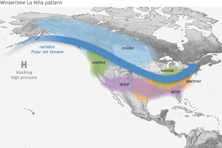
I hear that 2017-18 is supposed to be a La Nina year, meaning moderately drier and warmer winter. So I am not hopeful of seeing much snow this year. In case you were wondering, the winter that produced the Blizzard of 1973 was a strong El Nino year and the ice storm of 2004 was a weak El Nino year. So come on baby girl (La Nina), give us a break this year, after all it has been a heck of a hurricane season this summer.So whether Mother Nature has a baby boy (El Nino) or a baby girl (La Nina) I hope you get the winter weather you want this year. Oh MY!

No comments:
Post a Comment